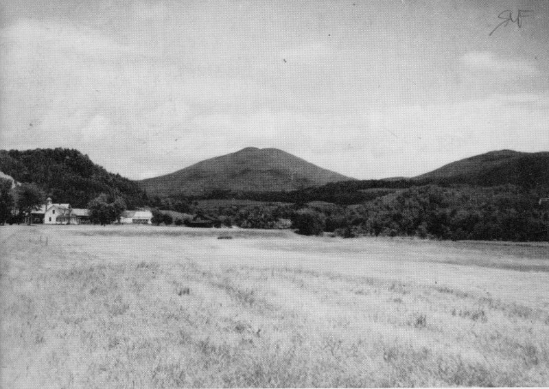
Cover picture: View of Burke Mountain (center, background). Picture taken towardthe northeast from State Route 114, about 5 miles south of East Burke.
THE GEOLOGY OF
DARLING STATE PARK
By
HARRY W. DODGE, JR.
VERMONT GEOLOGICAL SURVEY
Charles G. Doll, State Geologist
DEPARTMENT OF FORESTS AND PARKS
Robert B. Williams, Commissioner
DEPARTMENT OF WATER RESOURCES
1967
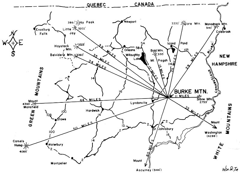
Figure 1. Map showing the location of Burke Mountain (Darling State Park),and mountain peaks which can be seen from the summit of Burke Mountain.
| Jay Peak | 39 MILES | 3861′ |
| Gore Mtn. | 25 MILES | 3330′ |
| Monadnock Mtn. | 29 MILES | 3140′ |
| Haystack Mtn. | 35 MILES | 3223′ |
| Belvidere Mtn. | 34 MILES | 3360′ |
| Willoughby Lake | 15 MILES | |
| Bold Mtn. | 15 MILES | 3315′ |
| Mount Mansfield | 44 MILES | 4393′ |
| Stone Mtn. | 11 MILES | 2753′ |
| Mount Washington | 35 MILES | 6288′ |
| Camels Hump | 50 MILES | 4085′ |
| Mount Ascutney | 80 MILES | 3144′ |
THE GEOLOGY OF DARLING STATE PARK
By HARRY W. DODGE, JR.
INTRODUCTION
Darling State Park, located in northeastern Vermont (see map, “BurkeMountain,” Fig. 1), offers outstanding opportunities to the camper,picnicker, hiker, view-seeker and winter sportsman. On a clear day thetop of Burke Mountain offers a most spectacular view of northeasternVermont and such distant points as Mount Ascutney (located on theConnecticut River, some 80 miles as the crow flies, to the south). Otherprominent peaks that may be seen are Camels Hump (50 miles southwest),Mount Mansfield (44 miles west), Jay Peak (39 miles northwest),and Mount Washington (the highest Peak in the New England Statesand the northeast, which is located in New Hampshire some 47 milessoutheast of Burke Mountain). For the traveler, the view from BurkeMountain reveals “where he has been” and where he might “next go.”See Figure 1 for the location of points which can be seen from the overlooksatop Burke Mountain.
Both the professional and amateur naturalist will find Darling StatePark extremely interesting. This pamphlet is devoted primarily to thegeology of the park, but the fauna and flora o